
Aerial archaeology
Aerial archaeology is the study of archaeological sites from the air. It is a non-invasive method of archaeological investigation that uses aerial photography, remote sensing, and other techniques to identify, record, and interpret archaeological features and sites. Aerial archaeology has been used to discover and map a wide range of archaeological sites, from prehistoric settlements and ancient roads to medieval castles and World War II battlefields.
History
[edit]The origins of aerial archaeology can be traced back to the early 20th century, when the first aerial photographs were taken during military reconnaissance missions in World War I. One of the earliest pioneers was Lt. Henry S. Wellcome, who in 1906 used a kite to take aerial photographs of archaeological sites in the Sudan. However, it was O.G.S. Crawford, an English archaeologist working in the 1920s, who is widely considered the "father of aerial archaeology." Crawford recognized the potential of aerial photography for archaeological research and conducted extensive surveys of the English landscape from the air. He published numerous articles and books on the subject, laying the foundation for the development of aerial archaeology as a scientific discipline.
During and after World War II, the development of more advanced aerial cameras and the increasing availability of planes and aerial platforms expanded the use of aerial archaeology. Significant projects included surveys of Roman roads and settlements in Britain and the discovery of previously unknown archaeological features across Europe. Since then, aerial archaeology has continued to grow as an important method for archaeological research.
Brophy and Cowley argue that "recording techniques in any one country or region are bound up in archaeological tradition that are heavily influenced by social and political contexts."[1] Thus, aerial photography is recognized as a key part of archaeological survey in Britain, partly because it has strong local roots, especially through the RAF. However, this is not true everywhere.
Pioneers of aerial archaeology include:
- O. G. S. Crawford (England): Pioneered the use of aerial photography for archaeological survey.
- Roger Agache (France): A leading figure in the development of aerial archaeology in France, known for his work on Gallo-Roman sites.
- Antoine Poidebard (Syria): Used aerial photography to study Roman limes in the Middle East.
- Dache McClain Reeves (United States): A pioneer in the use of aerial photography to study Native American archaeology in the United States.
- Henry Wellcome (Sudan)
- Lionel Rees (Jordan)
- Giacomo Boni (Italy)
Details
[edit]Aerial archaeology involves interpretation and image analysis of photographic (and other kinds of images), in field research to understand archaeological features, sites, and landscapes. It enables exploration and examination of context and large land areas, on a scale unparalleled by other archaeological methods. The AARG (Aerial Archaeology Research Group) boasts that "more archaeological features have been found worldwide through aerial photography than by any other means of survey".[2]
Aerial archaeological survey combines data collection and data analysis.[3] The umbrella term "aerial images'" includes traditional aerial photographs, satellite images, multispectral data (which captures image data within specific wavelength ranges across the electromagnetic spectrum)[4] and hyperspectral data (similar to multi-spectral data, but more detailed).
A vast bank of aerial images exists, with parts freely available online or at specialist libraries. These are often vertical images taken for area surveys by aircraft or satellite (not necessarily for archaeological reasons). Each year a small number of aerial images are taken by archaeologists during prospective surveys.[5]
Aerial archaeology is used for a wide range of archaeological purposes including the discovery of new sites, site recording, determining where to excavate, mapping individual sites, and monitoring sites. Aerial images form the foundation of archaeological landscape mapping and the ability to study large areas is often the only possible using aerial resources.[6]
Through the aid of vast data banks of satellite and other aerial imagery, archaeologists have access to resources that allow them to carry out these tasks.
In places yet to be documented (or where maps are considered confidential), satellite imagery is vital to providing base maps for excavation.[7]
For data analysis, aerial images must be analysed and interpreted using specialised skill-sets. This includes an understanding of formation processes as well as contemporary history and landscape history.[8] Often aerial archaeology will be carried out using computer programmes (such as Geographic Information System) aiding interpretation.
Despite aerial photography seeming methodologically objective and empirical, there is possible subjectivity that merits consideration, e.g. bias when interpreting images, and errors such as conflating interpretation with description.[9] In 'From the Air: Understanding Aerial Archaeology', Brophy and Cowley argue that "the individual plays a major role in creating the archaeological record"[10] in aerial archaeology, more than in other fields. For example, in aviation archaeology, subjective decisions include deciding where and when to fly, what targets to examine, what to photograph and how to photograph it, what to catalogue, and how to interpret the data.


Methods
[edit]Identifying archaeological features from above
[edit]Certain archaeological features are more visible from the air than on the ground due to their nature.
A key concept behind interpretation in aerial archaeology is that formation processes affect site features differently after abandonment. For a site to be detected by a remote sensing method, one would expect alterations to the soil or subsoil e.g. ditches, pits, banks, mounds, walls etc. which often are visible in relief.[11]
Tiny differences in ground conditions caused by buried features can be emphasised by a number of factors and viewed from the air:
- Shadow marks: slight differences in ground levels will cast shadows when the sun is low and are best from above.
- Cropmarks: buried ditches will hold more water and buried walls will hold less water than undisturbed ground, which causes crops to grow taller or shorter, and therefore define buried features, e.g. as tonal or colour differences.
- Frost marks: frost can also appear in winter on ploughed fields where water has naturally accumulated along the lines of buried features.
- Soil marks: slight differences in soil colour between natural deposits and archaeological ones can also often show in ploughed fields as.
- Water pooling: differences in levels and buried features will also affect the way surface water behaves across a site, producing striking effects after heavy rain.

Diagram showing shadows and highlights from the sun, as would be seen from above, falling on a mild bank and a steep bank. (Diagram prepared by author) 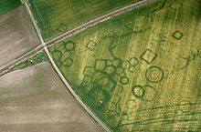
Cropmarks at a protohistoric site at Grézac, France 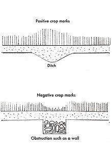
Effects of sub-soil features on the growth of crops. This allows for diagnosis of sub-soil features by visual inspection of crops using aerial images. (Diagram prepared by author)


Aerial Photography
[edit]This is the most common method used in aerial archaeology. Archaeologists use specialized cameras and lenses to capture high-resolution images of the ground from aircraft or drones.
Oblique Images
[edit]Oblique images are taken at an angle, allowing sunlight to highlight physical features on the ground through shadow.[11]
These are often taken intentionally to observe something of potential archaeological significance. The day and time of year are essential for the most revealing images. Furthermore, features must be recognized before being photographed.
Vertical images
[edit]Vertical images are taken with no deviation from a perpendicular angle (the image looks straight down). These make up the majority of images in the vast public (and private) image catalogues used by archaeologists. Vertical images record entire landscapes and are often used for site discovery, as well as landscape survey, placing sites in their wider context, and mapping larger areas.[2]
For a three-dimensional effect, an overlapping pair of vertical photographs, taken from slightly offset positions, can be viewed stereoscopically.

Photogrammetry
[edit]This technique uses overlapping aerial photographs to create 3D models of archaeological sites and landscapes.[12]
Remote Sensing
[edit]LiDAR
[edit]
LiDAR (light detection and ranging) aka ALS (airborne laser scanning) uses laser scanner pulses that are beamed to the ground, from an aeroplane, and bounce back recording the landscape features. This is used to document topography, creating visualisations of the data such as digital elevation models.[8] This allows archaeologists to penetrate dense foliage, such as tree canopies, that could not easily be surveyed at such a large scale on land.[citation needed]
Thermal Infrared Imaging
[edit]Detects differences in heat radiation, which can reveal buried structures or variations in soil composition.
NASA LANDSAT series
[edit]The NASA LANDSAT series (satellite observations) are often used in aerial archaeology. Renfrew and Bahn describes the techniques used as scanners that "record the intensity of reflected light and the infrared radiation from the earth surface and convert these electronically into photographic images."[13] LANDSAT images have helped in identifying large-scale features, such as an ancient riverbed running from the Saudi Arabian desert to Kuwait.[14]
IKONOS and QuickBird
[edit]Satellites whose images are publicly available, include IKONOS and QuickBird. These images can be used similarly to aerial photographs, with high resolutions of 1m and 60 cm respectively. NASA Worldwind offers worldwide cover, at the cost of resolution.[7]
Google Earth
[edit]A useful way to access many of the satellite images (mentioned above) is through Google Earth. This includes a range of different satellite and aerial images, such as the NASA LANDSAT series, IKONOS, QuickBird, GeoEye alongside more.[7]
CORONA
[edit]The Cold War CORONA satellite photographs have been used extensively for base maps and provisional interpretation.[7] In contrast to other imagery, CORONA uses two images of the same feature to create a stereoscopic view, which can allow for more accurate examination and interpretation in 3D.[2]
Non-visible wavelengths (airborne/spaceborne)
[edit]SLAR
[edit]SLAR (sideways looking airborne radar) is a remote sensing technique that records pulses of electromagnetic radiation from an aircraft. Richard Adams used SLAR to identify a matrix of possible Mayan water irrigation systems underneath the dense rainforest from a NASA aircraft.[7]
SAR
[edit]SAR (synthetic aperture radar) involves radar images that are processed to create high-resolution data.[7] This technique stands out, as weather conditions and nightfall do not affect its results. Renfrew and Bahn describe it as a "rapid non-destructive alternative to surface survey that does not involve the collection of artefacts."[15] It can be faster and less time-consuming than surface survey.
ASTER
[edit]Advanced spaceborne thermal emission and reflection radiometer (ASTER) used to create maps of "land surface temperature, reflectance, and elevation."[15] It is attached to the side of satellite Terra and can be used to create digital elevation models.

Uses
[edit]- Site Discovery and Mapping: Aerial photography and remote sensing can reveal buried features that are not visible from the ground, leading to the discovery of new archaeological sites.
- Landscape Archaeology: Provides a broad perspective on the relationship between archaeological sites and their surrounding environment.
- Monitoring and Management of Sites: Aerial archaeology can be used to monitor the condition of archaeological sites and assess threats such as erosion or looting.
- Reconstruction and Interpretation: Aerial images can be used to create 3D models and visualizations of archaeological sites, aiding in their reconstruction and interpretation.
Geometric or perspective distortions in the resulting images are often rectified using computer programmes. Additionally, these images can be geo-referenced by computer programmes. Images can be layered a GIS (Geographical Information Systems) or graphics software through which interpretations can be made.[8] Orthophotos, 3D models and more, can be created.
Due to the high-resolution nature of many of these aerial image types, the precise location of sites and excavation trenches can be planned and mapped.[7]
Furthermore, large areas can be surveyed using overlapping images which can be translated into an accurate base map of all visible archaeological evidence.
Digital data, for example, ALS, can be used effectively in "heavily automated workflows" [12] (a process that uses rule-based logic to launch tasks that run without human intervention), e.g. a six-year project using supervised automated classification to survey 35,000 km2 (14,000 sq mi) of Baden-Wurttemberg in Germany, identified as many as 600,000 possible sites.[12]

Case Studies
[edit]- Nazca Lines, Peru: Aerial photography played a crucial role in documenting and understanding the enigmatic Nazca Lines, giant geoglyphs etched into the desert.
- Angkor Wat, Cambodia: Aerial laser scanning (LiDAR) has been used to map the extensive temple complex of Angkor Wat and its surrounding landscape, revealing previously unknown features.
- Caracol, Belize: LiDAR surveys have helped to map the ancient Maya city of Caracol, revealing its size and complexity.
- Roman Limes in the Middle East: Antoine Poidebard's pioneering work using aerial photography to document the Roman frontier fortifications.
Caracol, Mayan City
[edit]Aerial archaeology, specifically LIDAR, was used to study Caracol, a Mayan city in Belize, dated to 550-900 AD. Archaeologists Arlen and Diane Chase, from the University of Central Florida, worked for 25 years in the dense tropical rainforest, managing to map 23 km2 (8.9 sq mi) of settlement. At the end of the dry season of 2009, they embarked on four continuous days of LIDAR flying, followed by three weeks of analysis by remote sensing experts. This allowed them to surpass the results of the prior 25 years, revealing over 177 km2 (68 sq mi) of city—a far larger area than expected. Furthermore, the landscape was modelled in 3D, leading to the discovery of possible new sites such as "ruins, agricultural terraces and stone causeways"[16] (to be investigated further for a greater understanding). We can thus see the impressive effect aerial methods can have on streamlining archaeological survey, and pushing the limits of what is possible.[citation needed]
Homs, Syria
[edit]Homs, Syria provides an example of how different types of satellite imagery can be used in combination. The site is based in an area notorious for its difficulties surrounding archaeological survey, as the diversity of terrain makes the detection of archaeological sites difficult. As a result, Homs is a perfect candidate for aerial reconnaissance. Modern agriculture often obscures remains through practices such as deep ploughing (which removes many levees and low-lying sites from the archaeological record).[14] Furthermore, vegetation of different types/densities frequently disguises sites, impeding site visibility.
The Homs projects combined the usage of CORONA, LANDSAT, IKONOS, and Quickbird imagery to observe "long-term human and environmental interactions"[14] and, more broadly, to assess the landscape, over an area of 630 quare kilometres that had no prior database of remains or aerial photography. Through fieldwork, the different applications and abilities of these satellite imagery techniques were revealed, highlighting the importance of using multiple methods of archaeological investigation together.
The LANDSAT imagery fell short when used for site detection and mapping, due to its lower resolution compared to Quickbird and IKONOS, but was most successful at characterizing the environment and visualizing rates of change.[14]
CORONA imagery successfully detected single-period sites, which could not be detected by IKONOS. Furthermore, CORONA imagery assisted in exposing ancient field systems, and crop marks within fields, revealing early watercourses.[14]
In this instance, visual detection and interpretation of satellite imagery proved more useful than processing LANDSAT imagery.[14]
Through interpretation archaeological sites were identified as tells with low-relief soil markings, "with remains ranging from small walls less than 1 m wide to large multi period settlements."[14] The projects as a whole demonstrated how valuable aerial archaeology is to archaeological survey, especially across terrains where other techniques are not possible.
See also
[edit]References
[edit]- ^ Brophy, K. and Cowley, D. (2005). From the air: Understanding aerial archaeology. Stroud, Gloucestershire: Tempus publishing limited. p.13
- ^ a b c "Introduction to Aerial Archaeology". Aerial Archaeology Research Group. Retrieved 2022-05-13.
- ^ Renfrew, C. and Bahn, P. (2016). Archaeology: Theories, Methods and Practice. High Holborn, London: Thames & Hudson Ltd. p. 80.
{{cite book}}: CS1 maint: multiple names: authors list (link) - ^ Suguayani. "Multispectral image". Imagine Info. Retrieved 2022-05-13.
- ^ Renfrew, C. and Bahn, P (2016). Archaeology: Theories, Methods and Practice. High Holborn, London: Thames & Hudson Ltd. p. 81.
{{cite book}}: CS1 maint: multiple names: authors list (link) - ^ Renfrew, C. and Bahn, P. (2016). Archaeology: Theories, Methods and Practice. High Holborn, London: Thames & Hudson Ltd. p. 84.
{{cite book}}: CS1 maint: multiple names: authors list (link) - ^ a b c d e f g Renfrew, C. and Bahn, P. (2016). Archaeology: Theories, Methods and Practice. High Holborn, London: Thames & Hudson Ltd.
- ^ a b c Cowley, Dave (2012). Interpreting Archaeological Topography : Lasers, 3d Data, Observation, Visualisation and Applications. Oxbow Books Ltd. OCLC 815945744.
- ^ Brophy, K. and Cowley, D. (2005). From the air: Understanding aerial archaeology. Stroud, Gloucestershire: Tempus publishing limited.
- ^ Brophy, K. and Cowley, D. (2005). From the air: Understanding aerial archaeology. Stroud, Gloucestershire: Tempus publishing limited. p. 14.
{{cite book}}: CS1 maint: multiple names: authors list (link) - ^ a b Deuel, Leo (1973). Flights into Yesterday : the story of aerial archaeology. Penguin Books. ISBN 0-14-021626-X. OCLC 963497702.
- ^ a b c Renfrew, C. and Bahn, P. (2016). Archaeology: Theories, Methods and Practice. High Holborn, London: Thames & Hudson Ltd. p.85
- ^ Renfrew, C. and Bahn, P. (2016). Archaeology: Theories, Methods and Practice. High Holborn, London: Thames & Hudson Ltd. p.90
- ^ a b c d e f g Parcak, Sarah H. (2009). Satellite Remote Sensing for Archaeology. Routledge. ISBN 978-0-415-44878-9. OCLC 1291927464.
- ^ a b Renfrew, C. and Bahn, P. (2016). Archaeology: Theories, Methods and Practice. High Holborn, London: Thames & Hudson Ltd. p.92
- ^ Renfrew, C. and Bahn, P. (2016). Archaeology: Theories, Methods and Practice. High Holborn, London: Thames & Hudson Ltd. p.89
- Bibliography
- Bourgeois, J. and Meganck, M. (eds.) (2005). Aerial Photography and Archaeology 2003. A Century of Information. Archaeological Reports Ghent University 4. Ghent: Academia Press. ISBN 90-382-0782-4
- Brophy, K. and Cowley, D. (2005). From the air: Understanding aerial archaeology. Stroud, Gloucestershire: Tempus publishing limited.
- Brophy, K. and Cowley, D. (eds.) (2005). From the air: understanding aerial archaeology. London: The History Press. ISBN 0-7524-3130-7
- Deuel, L. (1973). Flights into Yesterday : the story of aerial archaeology. Penguin Books. ISBN 0-14-021626-X. OCLC 963497702.
- Opitz, S. and Cowley, D. (2012). Interpreting Archaeological Topography : Lasers, 3d Data, Observation, Visualisation and Applications. Oxbow Books Ltd. OCLC 815945744.
- Parcak, S. (2009). Satellite remote sensing for archaeology. Routledge. ISBN 978-0-415-44878-9. OCLC 1291927464.
- Renfrew, C. and Bahn, P. (2016). Archaeology: Theories, Methods and Practice. High Holborn, London: Thames & Hudson Ltd
- Riley, D. N. (1987). Air photography and archaeology. Univ of Pennsylvania. ISBN 0-8122-8087-3
- Suguayani. "Multispectral image". Imagine Info. Retrieved 2022-05-13.
- Wilson, D. R . (2000). Air photo interpretation for archaeologists, London: The History Press. (2nd edn.). ISBN 0-7524-1498-4
- "Introduction to Aerial Archaeology". Aerial Archaeology Research Group. Retrieved 2022-05-13.
External links
[edit]- Emporia State University: Aerial Archaeology
- Aerial and Remote Sensing Archaeology Link and Reference Site
- Aerial Archaeology. AerialArchaeology.com focuses heavily on near-earth imaging technologies such as kite aerial photography, remote-control powered parachutes, balloons, and model airplanes and helicopters. *** Off-line April 20, 2010 ***
- ACE Foundation
- Kite Aerial Photographers - Archaeology
- Sir Henry Wellcome
- Aerial Archaeology in Northern France
| History | |||||||||
|---|---|---|---|---|---|---|---|---|---|
| Method and theory | |||||||||
| Sub-disciplines |
| ||||||||
| Lists | |||||||||
| Authority control databases: National |
|---|